
Wednesday, September 30, 2020
NEWS RELEASE- Sequoia National Park to Reopen Thursday, October 1
Tuesday, September 29, 2020
Mineral King / Silver City / Cabin Cove Downgraded to Voluntary Evacuation Warning
From the Tulare County Sheriff's Office, 1:00 p.m. September 29, 2020
SEQUOIA FIRE UPDATE: Sheriff Downgrades Some Evacuation Orders & Removes Others from Warning List
Sheriff Boudreaux has downgraded the following areas from an Evacuation Order to a Voluntary Evacuation Warning:
-Silver City
-Mineral King
-Remainder of South Fork Drive
-Residents on Blue Ridge Drive
An Evacuation Warning means people living in the area are able to return to their homes, but should still be ready to evacuate should fire conditions change. These areas will continue to have check points and residents with proof of residency will be allowed to enter the area.
Areas REMOVED from Evacuation Warning List:
-Three Rivers area, including but not limited to, areas of Three Rivers, South Fork Drive (below Conley Bridge), south of Heidi Drive and Cherokee Oaks
-Balch Park, including Bear Creek to Rancheria Fire Road and Balch Park Road to Blue Ridge Drive
All remaining Evacuation Orders and Evacuation Warnings remain in place. Crews continue to work and travel in the area. Please do not travel into these communities, as extra traffic can impact the ability for crews to quickly get in and out of the fire area.
As residents return to their homes, please be sure to arrange for your animals that may be in a shelter to return home. You can reach out to Tulare County Animal Services to make those arrangements.
Reminder that the Sequoia Kings National Park remains closed to visitors, and the Sequoia National Forest remains closed to all visitors.

Monday, September 28, 2020
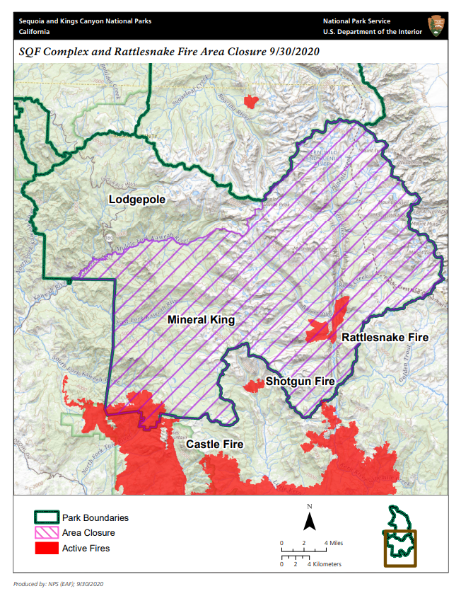
SQF Complex Fire Update
Things are looking better for the SQF Complex Fire, now 50% contained as of this morning (Monday, September 28). The north flank of the fire is located about 9-10 miles south of the Mineral King Valley, and is progressing very slowly due to the terrain. A Silver City resident sent this note today: "I just received a text from a firefighter friend who was sent up to Mineral King over the weekend. He said things were looking really good; the fire is staying away from us. This is great news! On a side note, this was his first trip up the hill. He is smitten with the beauty and wants to go back."
The Mineral King Road is still closed to all traffic from the Oak Grove Bridge to the end of the road at East Mineral King, but we're hoping for access soon so owners can prepare their cabins for the winter.
To follow the latest news on the SQF Complex Fire, click on this link which gives a lot of detailed and updated information:
Brief videos from CalFire Tulare County and U.S. Forest Service - Sequoia National Forest are posted in our Mineral King Facebook Group (you must have a Facebook account to view).

Saturday, September 19, 2020
Mineral King, Silver City, Cabin Cove Under Mandatory Evacuation
Friends,
At 2 PM today (September 18, 2020), the Tulare County Sheriff's Office issued a Mandatory Evacuation notice for Mineral King and Silver City. The CHP is blocking the Mineral King Road outside of the park. In conjunction with the evacuation order from Tulare County, the Superintendent has issued a closure order to the Mineral King area - including residents. I hope you used the voluntary evacuation time to tidy up your affairs.
I am hopeful that our recent wildfires and prescribed fires will provide an effective barrier to a wildfire becoming out of control in the MK Valley. I anticipate when the closure and evacuation order are canceled we will move to winter operations, precluding visitors and recreation for the remainder of 2020. For now, the Cold Springs water system is being shut down to protect infrastructure.
Based on the recommendation from the Cal Fire team and under mandatory evacuation orders before you reach the park, I am not in a position to permit any access at this time. Please let me know if you have any other questions.
Thanks,
Dave Fox
Sequoia District Ranger
 559-565-3710 office
Monday, September 14, 2020
Mineral King Road Closed Due to Wildfire
Note: Cabin owners are allowed access to their personal property. If you drive up, be sure and bring BOTH the old (last year) and new lock codes, as the locks may not have been changed yet.
|


Monday, September 7, 2020
Critical Fire Danger!
Sequoia and Kings Canyon National Parks News Release
For Immediate Release
Contact: Fire Information Office
Phone Number: 559-565-3704
E-mail: seki_fire_info@nps.gov
Reference Number: 8550-2023
Sequoia & Kings Canyon National Park Enact Parks-wide Campfire Ban
SEQUOIA AND KINGS CANYON NATIONAL PARKS, Calif. September 7, 2020 – Due to extreme fire danger, record setting temperatures, commitment of firefighting resources across the area and state, and national and geographical preparedness levels at PL-5, their highest levels, the parks are increasing fire restrictions.
Effective at 6:00 a.m. on September 8, 2020, Sequoia and Kings Canyon National Parks are enacting a parks-wide campfire and smoking ban. This includes all campgrounds, picnic and day-use areas, and wilderness locations inside the parks. There are no exceptions to this change.
"We need the public and our visitors help in preventing any new wildfires at this critical time," said John Ziegler, parks' fire management officer. "One less spark means one less fire."
The increased fire restrictions can be summed up to be:
Wood and charcoal fires (including wood-burning stoves) are illegal at all elevations and locations.
Employee housing and private property throughout the parks are included.
Gas, propane, alcohol (with and without a shutoff valve), and tablet/cube stoves are permitted in all areas.
No smoking at any elevation except within an enclosed vehicle, a building in which smoking is allowed, or a designated smoking area.
These restrictions will remain in effect until conditions in the area have progressed to a point where minimal public hazard remains, as determined by the Parks' Superintendent.
For information on the other fire restriction stage levels, please visit https://go.nps.gov/sekifirerestrictions
Friday, September 4, 2020
Alles Cabin Undergoes Restoration

I'm glad to see the historic Alles Cabin (located across the road from the Atwell Mill Ranger Station) being repaired and restored. Read all about it here:
https://3riversnews.com/historic-alles-cabin-undergoing-nps-restoration/
Air Quality in the Mineral King Valley

We have been gifted with an air quality monitor at the Mineral King Ranger Station. Simply go to https://fire.airnow.gov/?lat=36.44310412654107&lng=-118.59157562255861&zoom=12.
The triangle color reflects the measured air quality index (AQI) and you can zoom out to see current flame locations as detected by satellite, as well as smoke coverage (when that feature is working). Although the monitor provides useful information, it is important to note that the monitor measures only fine particulates (PM2.5) which do not increase significantly with wildfires compared to other inhalable particulates and toxins. If you see and smell smoke, assume the air quality is unhealthy and take reasonable precautions.
Subscribe to:
Posts (Atom)